by Jocelyn Qassis , March 2026
From Escalation to Entrenchment
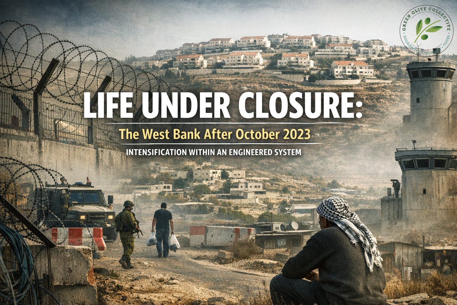
In the months following October 7, 2023, mobility across the West Bank tightened in ways that were immediately visible yet historically familiar. Entrances to Palestinian towns were sealed with earth mounds and metal gates. Flying checkpoints appeared without warning along major transport corridors linking northern and southern districts. Journeys that once required predictable travel times became subject to sudden rerouting, delay, or denial.
While widely framed as emergency security measures, these restrictions unfolded within an already entrenched system of spatial control. Closure in the West Bank is not an episodic interruption imposed upon an otherwise open geography. It is a layered administrative, military, and infrastructural framework that has shaped mobility for decades. What changed after October 2023 was not the existence of this system, but its intensity and volatility.
By 2026, intensified closure has shifted from reactive posture to normalized condition.
The Pre-Existing Architecture of Fragmentation
Even before the recent escalation, Palestinian movement operated within a dense matrix of physical and administrative constraints. The United Nations Office for the Coordination of Humanitarian Affairs (OCHA) documented more than 645 physical movement obstacles across the West Bank prior to October 2023, including permanent checkpoints, road gates, earth barriers, and restricted road segments.
Overlaying this infrastructure is the territorial division established under the Oslo framework, which designates over 60 percent of the West Bank as Area C territory under full Israeli civil and military control. Within Area C, Palestinian construction permits are rarely approved, infrastructure development faces structural limitations, and agricultural access often requires coordination with military authorities.
The result is not simply inconvenience but fragmentation: Palestinian towns and villages function within a geography segmented into enclaves, with mobility conditioned by regulatory approval and physical passage points.
October 2023 did not create this architecture. It intensified its function.
Escalation After October 2023: Intensification Without Structural Change
Following October 7, humanitarian monitoring documented a sharp increase in flying checkpoints and intermittent road closures at the entrances to Palestinian communities. Inter-district travel between the northern and southern West Bank became increasingly unpredictable. Thousands of Palestinian workers were prevented from accessing employment inside Israel after work permits were suspended, removing a significant income source for many households.
Tourism-dependent cities such as Bethlehem experienced renewed contraction. Internal trade slowed as transport unpredictability raised logistical costs and disrupted supply chains.
What distinguishes this phase is not the emergence of closure, but its compression. Movement became not only restricted, but volatile, adding uncertainty to an already segmented spatial system.
Settlement Expansion and Spatial Engineering
Movement restrictions must be understood alongside demographic transformation. In the early 1970s, the Israeli settler population in the West Bank numbered only a few thousand. Today, according to data from the Israeli Central Bureau of Statistics and monitoring organizations such as Peace Now, the settler population exceeds 700,000 across the West Bank and East Jerusalem combined.
Settlement growth has been accompanied by dedicated bypass roads, security perimeters, and restricted access zones that intersect Palestinian localities in ways that disrupt territorial continuity. Infrastructure does not merely connect settlements to Israel; it reorganizes space itself.
Recent years have also seen the expansion and legalization processes of outposts, some of which play a direct role in reshaping rural Palestinian life. For example:
- Evitar: established near the Palestinian town of Beita, south of Nablus, has become a focal point of land tension and protest.
- Homesh: originally evacuated in 2005, later re-established and formalized in legislative steps, influencing access patterns in surrounding areas.
- Givat Harel: part of a cluster of outposts northeast of Ramallah affecting agricultural access routes.
- Meitarim Farm: associated with grazing land disputes and mobility pressures in the South Hebron Hills.
These outposts are not isolated hilltop presences; they are embedded within road systems and security frameworks that reshape access to adjacent Palestinian agricultural lands. Movement restrictions and settlement expansion operate within the same spatial logic: differentiated mobility embedded in infrastructure.
Settler Violence and the Feedback Loop of Restriction
Humanitarian reporting since late 2023 has also documented a rise in settler-related incidents affecting Palestinian property and agricultural land. In rural areas, particularly in the Jordan Valley and South Hebron Hills, such incidents intersect with existing movement restrictions.
When farmers must coordinate access through gates or navigate limited road networks, the presence of nearby outposts compounds vulnerability. In some cases, sustained insecurity combined with restricted access contributes to gradual displacement pressures. Displacement does not always occur through formal eviction; it can unfold through accumulated unsustainability.
Movement restriction and localized violence therefore operate within a feedback loop. Limited mobility reduces economic resilience and community presence, while insecurity is cited to justify further tightening of access controls.
Economic Constraint and the Compounding Effect
The World Bank has consistently identified restrictions on movement and access, particularly in Area C as among the primary structural impediments to Palestinian economic growth. Limitations on land use, infrastructure expansion, and market connectivity are estimated to cost the Palestinian economy billions annually in unrealized productivity.
When intensified closure is layered onto this baseline, economic fragility compounds. Transport delays increase transaction costs. Investors hesitate in uncertain regulatory environments. Labor mobility contracts. Supply chains become vulnerable to interruption.
An economy constrained geographically cannot expand predictably.
The Reality in 2026: Normalized Unpredictability
By 2026, intensified closure has not fully receded. While patterns fluctuate, unpredictability remains embedded in daily life. Flying checkpoints continue to appear without consistent scheduling. Road entrances are periodically sealed. Travel planning incorporates contingency rather than certainty.
Students depart earlier than necessary because arrival times cannot be assumed. Healthcare workers adjust routes based on anticipated restrictions. Families calculate risk before movement.
The most significant transformation may be psychological: unpredictability has been normalized. What was once extraordinary disruption is now factored into routine.
Closure has shifted from escalation to entrenchment.
The International Dimension: Monitoring Without Structural Shift
International actors continue to document developments and provide humanitarian assistance. United Nations agencies issue regular reports. Economic monitoring continues through World Bank assessments. Diplomatic statements reaffirm commitments to de-escalation and negotiated resolution.
Yet despite extensive documentation, the underlying spatial structure remains largely intact. Financial assistance mitigates immediate humanitarian impact but does not fundamentally alter territorial fragmentation. Political engagement oscillates between crisis management and rhetorical reaffirmation of long-standing frameworks.
The paradox of 2026 is clear: the system is thoroughly documented, yet structurally unchanged.
Closure as Governance
The tightening of movement restrictions after October 2023 did not inaugurate a new paradigm in the West Bank. It reinforced and exposed the depth of one already in place. With hundreds of documented physical obstacles, a majority of land under restrictive planning classification, a settler population exceeding 700,000, and expanding outposts reshaping rural access patterns, spatial differentiation has become institutionalized.
Closure today operates not merely as a security response, but as a governing mechanism. It regulates access to land, labor, infrastructure, and opportunity. It shapes economic viability and influences demographic continuity. It conditions how individuals plan their days and how communities imagine their futures.
The central question confronting 2026 is not whether roads are periodically blocked. It is whether a system organized around differentiated mobility can generate sustainable stability without entrenching structural inequality.
When restriction becomes normalized, inequality becomes embedded in geography. And when inequality is embedded in geography, resolution becomes progressively more complex.
Sources & Further Reading
Amnesty International. Israel’s Apartheid Against Palestinians: Cruel System of Domination and Crime Against Humanity. 2022.
Human Rights Watch. A Threshold Crossed: Israeli Authorities and the Crimes of Apartheid and Persecution. 2021.
Israeli Central Bureau of Statistics (ICBS). Population in Localities Reports. Latest editions.
Peace Now (Settlement Watch). Settlement Population Data and Outpost Monitoring Reports. Ongoing.
Palestinian Central Bureau of Statistics (PCBS). Labor Force Survey Reports. Latest editions.
United Nations Conference on Trade and Development (UNCTAD). Report on UNCTAD Assistance to the Palestinian People. Annual reports.
United Nations Office for the Coordination of Humanitarian Affairs (OCHA). West Bank Movement and Access Updates; Humanitarian Situation Reports.
World Bank. Economic Monitoring Report to the Ad Hoc Liaison Committee; Area C and the Future of the Palestinian Economy.
Comment (0)