PALESTINE - ISRAEL - JORDAN - SINAI

Off the beaten track tours • Visit sites • Meet locals • Discuss Human Rights & Politics

Jordan Valley Annexation

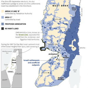
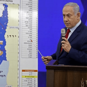
 – by Yahav Zohar – On 10 September 2019 (a week before the 2nd 2019 Israeli elections) Israeli prime minister Netanyahu announced his plan to annex the Jordan Valley, standing in front of a map incorrectly noting the location of some Israeli settlements and omitting several Palestinian villages. The next day, there was condemnation from […]

Read More

Palestinian cities are ghost towns between settlements, on Google Maps

 The notorious, massive Qalandiya checkpoint lies in the center area surrounded by three roundabouts. Qalandiya is the scene of relentless ethnic control, murders by the IDF, violently suppressed protests, and a major cause of the impossibility of normal civilian life and movement. On GoogleMaps, the checkpoint does not exist. – by Tom Suàrez, of Mondoweiss […]

Read More

On the Significance of Place-Names

By Miri – As a result of its turbulent history, of numerous conquests, occupations, and partitions administered by different powers, the official name of our region has been constantly changing. Similarly, its borders were and continue to be redrawn as a consequence of the struggles between different powers for control over the region as a […]

Read More


A Brief Modern History of the Palestine / Israel Conflict

 – 
by Yahav Zohar & the Green Olive TeamOttoman Period Israel and Palestine are two names for the same place, claimed by both the Zionist and Palestinian national movements. Despite often heard claims, this is not an ancient problem. For hundreds of years of Ottoman rule, the ethnic and religious groups here lived together in […]

Read More

Jerusalem Settlement Map

➞ Back to Index of Maps. This map is courtesy of the right wing Jewish settler organization, Beit Orot. You are encouraged to check them out at http://www.beitorot.org. They are well funded, well organized, and explicitly dedicated to altering the demographics of Jerusalem and forever thwarting the possibility of a Palestinian State with East Jerusalem […]

Read More

Israel Palestine West Bank Maps

➞ Back to Index of Maps. This sequence of maps takes you through the development of the political geography of the region. You can download individual maps or download the complete package of maps which includes all the maps below plus an additional 9 maps. This is a 10.5 MB file so it may take […]

Read More

Maps of Palestine & Israel

Index of Maps Political Geography Series of maps showing evolution of the Occupation of Palestine Download series of 17 maps. (10.5 MB) Jerusalem Settlements Palestinian Archipelago British Mandate 1920-1948 Theodore Hertzl’s Map of the Jewish State Ottoman Palestine Shrinking Map of Palestine Historical Maps – 970BCE – 1967CE Land Distribution – 1946-2000   Practical Maps […]

Read More

Map of British Mandate of Palestine 1920-1948

➞ Back to Index of Maps. ➞ Back to Index of Maps.

Read More

Theodor Herzl’s Map of the Jewish State

➞ Back to Index of Maps. In his Complete Diaries, Vol. II. p. 711, Theodor Herzl, the founder of Zionism, says that the area of the Jewish State stretches: “From the Brook of Egypt to the Euphrates.” Rabbi Fischmann, member of the Jewish Agency for Palestine, declared in his testimony to the U.N. Special Committee […]

Read More

Ottoman Palestine Map 1864-1871

➞ Back to Index of Maps. ➞ Back to Index of Maps.

Read More

Shrinking Map of Palestine 1947-2006

➞ Back to Index of Maps. ➞ Back to Index of Maps.

Read More

Historical Maps Israel/Palestine 970bce-1967ce

➞ Back to Index of Maps. ➞ Back to Index of Maps.

Read More
Fill out my online form.